

Background
During the Iron Age a variety of different types of settlement were constructed and occupied in south western England. At the top of the settlement hierarchy were hillforts built in prominent locations. In addition to these a group of smaller sites, known as defended settlements, were also constructed. Some of these were located on hilltops, others in less prominent positions. They are generally smaller than the hillforts, sometimes with an enclosed area of less than 1ha. The enclosing defences were of earthen construction. Univallate sites have a single bank and ditch, multivallate sites more than one. At some sites these earthen ramparts represent a second phase of defence, the first having been a timber fence or palisade. Where excavated, evidence of stone- or timber-built houses has been found within the enclosures, which, in contrast to the hillfort sites, would have been occupied by small communities, perhaps no more than a single family group. Defended settlements are a rare monument type. They were an important element of the settlement pattern, particularly in the upland areas of south western England, and are integral to any study of the developing use of fortified settlements during this period. All well-preserved examples are likely to be identified as nationally important.
The Earthworks (Scheduled Ancient Monument)

Despite slight damage by stock erosion, the earthwork enclosures and field systems 430m north east of Lower Well Farm survive well, the banks and ditches containing stratified remains relating to its construction and use, and necessary for the future understanding of the monument. Romano-British farmsteads are commonly square, single or double ditched enclosures, usually only surviving as buried features visible as cropmarks. Most examples belong to the first and second centuries AD. They were constructed with low earthen or rubble ramparts, excavated from one or two surrounding ditches, closely spaced. Despite slight damage from a track which crosses the site, the banks and surrounding ditches will contain stratified remains relating to the enclosure’s construction and use. Remains of the field system will provide additional information about farming practices used here between the Iron Age and post-medieval periods.
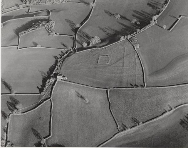
This monument includes a group of earthworks representing settlement and farming practices of Iron Age, Romano-British and late Roman date, on a gently sloping hilltop with wide views in all directions. A limestone pavement underlies the site. The monument survives as an ovoid earthwork enclosure, identified as a defended settlement, measuring a maximum of 170m from north west to south east across its visible earthworks, and at least 140m wide. The ramparts survive best on the north and east sides, where the inner bank measures from 2m to 4m wide, rising 0.7m from the interior and falling from 1m to 2m into an outer ditch 5m wide and from 0.2m to 0.5m deep. The bank gradually runs out to a shallow scarp on the west side, while on the east side the curvature is followed by two low banks 1.5m wide, 0.5m high and 8m apart. These terminate at an entrance. Inside this entrance, a small level area measuring 25m by 28m is enclosed by a bank from 2.5m to 5m wide and up to 1.2m high, with an outer ditch 3.5m wide and 0.5m deep on its north and east sides. This has a counterscarp bank 3m wide and 0.4m high. A terrace 2.5m wide on the south side falls away 1.3m for a distance of 3m. Excavations in 1958-1960 showed this smaller inner enclosure to have been occupied in the first and second centuries AD. A bank 2.5m to 5m wide and from 0.3m to 1.5m high, projects from the west side of the square enclosure into the centre of the ovoid enclosure for 66m to the north west. Small sub-rectangular fields to the east and south east are subdivided by banks from 2.5m to 5m wide and up to 1m high. A circular hut which survives as a bank 3m wide and 0.6m high enclosing a semcircular area 6.5m wide, was found during the excavations to have been occupied during the fourth century AD. Three long medieval cultivation terraces on the south west side of the site measure from 12m to 29m wide, with scarps 3m to 5m wide and up to 1.5m high. Open field cultivation in the field to the south continued until the mid-19th century. A series of small irregular quarry pits 5m to 10m wide and 0.8m deep on the eastern side of the scheduling were excavated to provide stone for the post-medieval wall alongside. All track surfaces, fence posts and a farm building which stands at the western corner of the site are excluded from the scheduling, although the ground beneath all these features is included.
